Sunday, July 3, 2011

Introduction


Nepal is a mountainous country . it is situated on the lap of Himalayas. It is a small countary. It is about 500 milies long and 100 milies wide. The population of the countary is about 20 million.

Nepal can be divided into three geographical regions . The himalayas are in the north. It is cold in this region . The land is covered with snow. People rear animals. The people of Mongolian race mainly live in this region . There are hills and narrow valleys in the central part. People are mainly farmers. They grow fruits and vegetables. The famous like kathmandu and pokhara lie in this region. The climate is pleasant . There are plains in this southern part. It is called the terai region . the soil is fertile. People are mainly farmers. They produce rice, wheat, maize and fruits. This region is known as the greenery of Nepal. It is very hot.

Nepal is a Hindu kingdom. The majority of the people are Hindu. But people can follow any religion they like. Some of people are Buddhists, some are muslims and some are Christians. The people fallow different customs, speak different languages and wear dif
ferent clothes. But there is unity among diversity .People are united

PHYSICAL


  Nepal is a country of diversity . there are great geo-physical,climate  and biological diversities that have resulted diverse  socio-economic and cultural pattern in the country.It is the country that lies in the youngest fold mountain, Himalayan of the world. It ranges from about 60 meters elevation to the 8848m, the highest point of the world. From the  climatic point of view, it ranges from tropical to the tundra from south to north .
The southern belt is almost plain land and the northern belt is rocky and mountainous where there are thousands of snow peaks. The mahabharat  range that lies in between these two belts is the gently slopping land having river valleys and tars. This belts is gently slopping in the eastern parts and more steep in the western part.

The country is mainly drained by the three major river system namely koshi, gandaki and karnali from east to west respectively.

From the economic point of view, the terai is the extensive agricultural belt, the mid land is the fruit and gain crops growing area and the northern part is a very beautiful area suitable for touristic activities and livestock farming as well. In this way, diversity has been reflected in economic, social, cultural and other aspects of life. These make Nepal a unique countary in the map of the world.

POLITICAL


 (Administrative division)
  Nepal has six tiers structures of the administrative division . these structures from top to bottom are : development region, zone ,district, llaka, village development committee, municipality and ward. In Nepal, there are five development regions ,14zones,75districts and 3913 VDCs. There are16 districts in EDR and 19,16,15 and 9 districts in the CDR,WDR,MWDR and FWDR respetively . Out of 14 zones, karnali is the largest and mahakali is the smallest in terms of area. Similarly, Dolpha  is the largest district and Bhaktapur is the smallest.
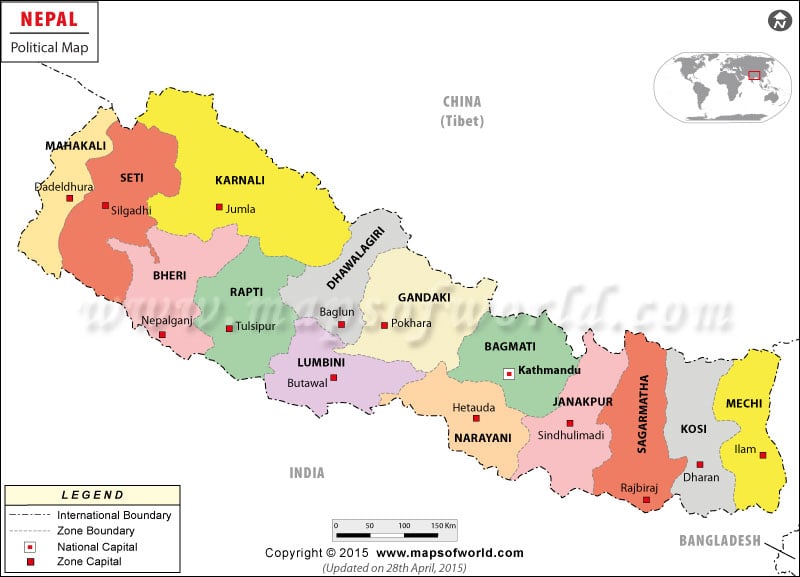
Each administrative division has its own headquarters. Dhankuta ,kathamandu ,Pokhara ,Birendranagar and Dipayal are the regional headquaters of the eastern, centeral,western,, Midwestern and farwestern development region respectively. Similarly, zones and districts also have their headquaters.Each VDC has its VDC office.

ECOLOGICAL DIVISION


   Nepal  has divers geo-ecological setting. It is the countary of diversity.On the basis of altitude Nepal is divided into three divisions. These are mountain,hill and terai.
     
    The mountainous lies in the northernmost part. It covers about 35 percent land area where only about 7 percent cultivated land and about 8 percent population are found. The mountain lies above the altitude of 3000 metre where there is a large number of mangnificent snow-covered mountainous,including the highest peak (Mt.Everest 8848m)of the world . it coveres about 42 percent land area, 44.5 percent population and 37 percent cultivated land. It lies between 600m to 3000m altitude. This region comparise several attractive peaks, fertile valleys and river basins.The terai lies in the southern part of  the country. It is elevated up to 600 meters from the sea level. It  comparies 23 percent of the total land area, 49 percent population and 56 percent cultivated land . it has been formed out of alluvium brought and deposited by rivers. The land is fertile for agriculture where wide varieties of crops are grown.

PHYSIOGRAPHIC DIVISION


Physiographic refers to the study of surface land form characteristics, physiography of Nepal has been mainly divided on the basis of river relief, structure, altitude and geographical distribution.
 
   Nepal is a mountainous countary ranging from 60 meter to the summit of the world (Mt Everest 8848m). There are thousands of river flowing from north to south forming gorges, river basins and  valleys. There is maximum relief , steep slop and geographical structures that have resulted distinct land forms and topography . For the sake of convenience, the physiography of Nepal has been divided as high himal, high mountain, middle mountain,siwalik and terai form north to south .

   Terai lies in the southern part . it is  the plain land of altitude below 600 meter. The alluvial deposit forms it. The churiya lies just north of terai, formed with conglomerates. Then the middle mountain extends widely. It lies between 900 to 3000 meter altitudes . it has spurs, hill,river  basins and valleys like kathmandu and pokhara . The high mountain also has steep and dissected land forms. The high himal is in the northernmost part where hundreds of snow peaks are found .

ELEVATION ZONES

The elevation of Nepal ranges from about 60 meter to the summit of the world , Mt Everest 8848 meter. The contour lines that represent the Z dimension (height) clearly show the altitude of the different parts of the country . Elevation goes on increasing from  south to north . The terai belt is the lowest in elevation . The altitude below 1000 meter covers about 36 percent area of the country .Similarly about 55 percent area lies in the altitude of 1000-5000 meter and remaining about 9 percent area lies above the altitude of 5000 meter. More specifically ,about 1 percent area lies above 6000meter  that is covered by mountainous peaks . Similarly about 23 percent area lies below 500 meter elevatio